Active Weather To Continue Through Third Week Of February
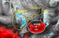
A very active weather pattern will continue into the third week of January. There will be numerous weather systems that track through with some spinning up into something formidable, while other are not much more than a mere nuance. Regardless on the strength of weather systems, a continuous stream of chilly Canadian air will be sweeping through then northern Rockies, Midwest, and Northeast every few days on the backsides of each weather system. The first image shows the jet stream around the 13th of February with numerous weather systems riding through the flow. This will continue to bring areas of rain and snow to many regions of the country. The forecast models are not handling how each of these systems develops very well as it’s quite a messy pattern when you get numerous circulations creating chaos. However, the pattern is quite clear and it will remain active. There should be a few stronger storms that track through the highest use states of the Midwest and Northeast and should yield several days of high to very high nat gas use. The most likely period of colder temperatures would be around February 13-15th on the back side of a departing weather system and again on the Another storm would likely be right on its heels and bring another round of snow and cold to the northern US with additional cold to follow the 17th and 18th. Thereafter, there is plenty of data to suggest several days of warming will occur over all of the central and eastern US. We don’t doubt this will happen and believe many national forecasts will be calling for this to be the start of a warm end of February pattern. It may start that way around the 20-21st, but we believe it very well could be a trap. There are many factors our research suggests would make such a pattern sticking suspicious.
We believe the coming pattern over the next two weeks will remain active with continued cold and snow for the highest use nat gas and energy demand states of the northern US. This should continue to draw down reserves and support prices. Several of the weather systems will be fairly strong and we believe it will surprise the markets much like the previous cold events did. (Why it was such a surprise is the one thing we still aren’t sure about.) Be cautions as the markets may hear hype of a much warmer end of February pattern. We are not convinced its anything more than a trap.


