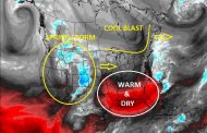
Tuesday, April 26th: Brazil’s 2nd crop corn belt received much needed rainfall over some areas the past few days after a prolonged period of hot and dry conditions. Recent rainfall has brought 0.40-2.50+”, but it has been a bit hit and miss with not all areas receiving enough to aid stressed late planted crops. While the rain is beneficial, it won’t last as the main feature triggering showers and thunderstorms shifts north out of the main growing areas after today. Essentially, much needed rainfall arrived to help some areas, but more is needed. The images below highlight recent rainfall with Doppler radar from last night showing widespread showers. The next image highlights the main 2nd crop corn growing belt, followed by rainfall amounts the previous day with areas of the 2nd crop corn belt receiving at least some rain. The last two images show rainfall forecasts for today, and then highlighting how drying will set up the rest of the week as showers push northward. Also note Argentina being dry with soybean harvest expected to progress, but more importantly allowing flooded or saturated areas to dry over the eastern growing regions. For the US, a stormy pattern is expected the next 7-10 days, starting with a strong Spring storm bringing severe weather to the central US today.


